"Two roads diverged in a yellow wood... And sorry I could not travel both. I took the one less traveled by. And that has made all the difference." --Robert Frost

Monday, October 5, 2015

Failure at Flagstaff

Flagstaff, AZ
Black Bart RV Park


On our way to visit friends and family in the Prescott/Phoenix areas, we spent a few days in Flagstaff.  We had wanted to boondock just north of the city so we could visit the Sunset Crater Volcano and hike Humphreys Peak, the highest point in Arizona.  The internet reception in the areas we wanted to stay was non-existent, so we moved down into Flagstaff at Black Bart's RV Park.

That is Mt. Humphrey, part of the San Francisco peaks, with the snow on top.
 

We always come upon some really amazing rigs. This one was a bit older 5th wheel being pulled by a really decked out truck.  They do some really amazing boondocking.  You can see the blue barrel behind the cab.  It is to carry extra fresh water.  They also had barrels for grey and black waste.  No toys were left behind.  They had bikes on the front, fishing boat up top and Harley in the back!
 
And on to the hike!  I've always wanted to hike the highest peak in each state, so I really wanted to conquer this one, but it got the last laugh.


This trail leads to the highest point in Arizona and runs approximately 5 to 5.5 miles in length one way.  You pass through alpine forests,  huge rock slides and avalanche tracks along the mountain's slopes. Hart Prairie stretches out at the base of the incline and the Grand Canyon is visible on the horizon. (although we did not see it, more on why later!)

Humphreys Trail is steep and long and extremely rocky. You have to be careful above the treeline as it can snow during any month of the year and in summer monsoon storms can bring lightning. We were lucky to catch the Aspen in full color.

It starts off harmless enough across a pretty meadow. You can see the peak in the back. (above)


Looking down the sloping meadow is a huge grove of Aspen.


Once we got into the trees, we found a lot of blow down and had to crawl over and under some of them.


  9
This was the nicest part of the trail.  It definitely is a very steep trail and as you got above the Aspen, the trail got rockier and rockier with very few smooth parts.  Good sturdy hiking boots with ankle support are very important to wear.
 
That is the trail.  These rocks were about the size of your foot.  Difficult to walk on the un-even surface.

One of the lava rock avalanches.

Looking down toward the valley floor.

Steve taking a rest.

Here comes the snow. This was about 8000ft.  I was surprised how many people were on the trail.  It really slowed us down to have to move to the side and let people pass going both up and some down.  We took more breaks as the straps on my camelback were starting to dig into my neck and giving me a headache. There weren't many views to see through the trees and the trail was getting more difficult.  We had to watch our time to make sure we would have enough time to get back down before it got dark
One of the few spectacular views.

We had passed a few people that had developed altitude sickness too.  Some had to turn around and head back down, some were throwing up on the trail and some were laying down along the trail trying to sleep off some of their illness.  I felt so bad for them.
s 
Well somewhere around 3pm we reached our turn around point.  We were surprised that we were not making as good of time as usual.  By this point my pack was causing a lot of stress on my neck and my head was pounding.  Then I felt the first wave of nausea.  It finally occurred to me that it was my turn for altitude sickness.  Back in California I'm used to hiking between 6000 and 9000 ft in elevation, but this caught me off guard.  It was worse when I stopped, so we tried to keep our pace on the way down.  I LOVE hiking.  But not today.  It was just miserable and I could not wait to get down.  We had about 3 hours to go.
 
 
The last view we had before turning around just before the saddle around 12K elevation. I'll fast forward.  I don't think we ever made such great time getting off a mountain.  Unfortunately, that made the altitude sickness worse.  I barely made it to the truck and was sick a few times before we drove the rest of the way down the windy road and back to camp. Took me a couple of days to feel better.  So, how did I like Humphreys Peak?  Hated it!  Would I try a repeat?  NO WAY!

Back to Black Bart's RV Park.  This was a medium sized private park.  Not our preference, but it worked.  $36, 10% off with Good Sam discount, full hook-ups.  Sites need a lot of work.  Concrete was badly cracked and broken.  The laundry was nice and they had a fantastic steak house.  Great internet and cell with some short easy hikes behind the park. 

 Never did make it to Sunset Crater.

Thursday, October 1, 2015

I'm Back! (A Day Trip to Lee's Ferry, AZ)

Paige, AZ
Paige Lake Powell Campground

I'm Back!!
 
It's good to be back!  First, thank you to all my kind followers who wondered what happened to me these past months.  Your calls and e-mails were so appreciated.  Nothing bad happened, I just got so busy with visits to family and friends both in Arizona and back in California for the holidays, I just found it impossible to catch up.  So I'll be doing my best to get caught up over the next couple of weeks while we are in Quartzite with fellow RVers during the month of January.
 
Ok, where did I leave off?  Oh yes, after our wonderful time in Antelope Canyon (see previous post) we took a day trip to visit Lee's Ferry.  It was a nice drive and the colors along the way were beautiful after a mornings rain. 

 
Driving across Route 89A, the Navajo Bridge crosses the Colorado River's Marble Canyon.  It will take you to Lee's Ferry or the North Rim of Grand Canyon.  Before the bridge was built, the only way to cross the river from Arizona to Utah was at nearby Lee's Ferry, where the canyon walls are lower.
 
A few facts about the Bridge:  
 

The original bridge was opened in 1929 and is the one on the left in the above picture.  It was decided after several years that a larger bridge was needed.  Instead of widening the original it was designated as a pedestrian and equestrian bridge.  There is a nice interpretive center too.  The new bridge (on the right) is for automobiles and was finished in 1995.
 
A beautiful view from the middle of the bridge.  Bungee jumpers are sometimes seen here.

A lock attached to the bridge.  If you haven't noticed these before, they are locks attached to bridges and other items by sweethearts to symbolize their love.  This was a pretty fancy one.  They usually have names or dates on them.  While the idea is cute, it has caused problems in many countries and the practice is illegal in some due to the damage they can cause.

After driving across the bridge over to Lee's Ferry the landscape opened up and there were some nice pull outs for pictures.


 Strange boulders appeared in one section.

This is called Balanced Rock.  Thousands of years ago huge boulders made of conglomerate broke off from the cliffs above and rolled down.  During that time several feet of the slope had eroded away from underneath creating these pedestals.

 
Due to its unique geography the only place for hundreds of miles where you can easily access the Colorado River from both sides was here at Lee's Ferry.  It served as an important river crossing and starting in the mid-19th century was the site of a ferry operated by John Doyle Lee, for whom it is named. Boat service at Lees Ferry continued for over 60 years before the Navajo bridge was built.
Lees Ferry also served as a military outpost and gold seekers.  It is also the principal point at which the river flow is measured to determine water allocations in the 246,000-square-mile Colorado River basin. Lees Ferry is the boundary between the Upper and Lower Basins of the Colorado River.

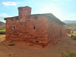
There are some old buildings left and some rusted equipment scattered around.  This is a popular place to put-in kayaks, rafts and boats.

We were here just before sunset and perhaps another time of day would have provided better lighting to capture some definition between the building and the cliffs behind it which were almost the same color.


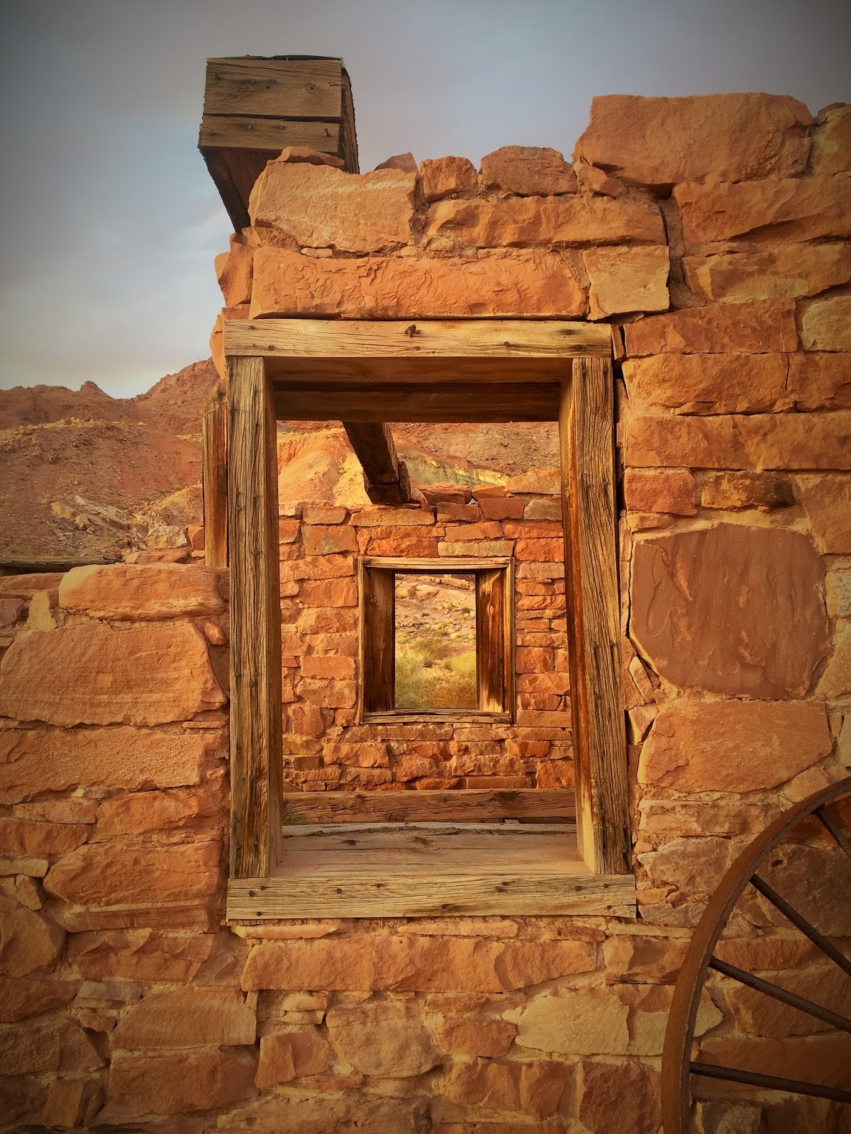
I fell in love with the remains of these windows and the views through them.


Lee's Ferry grew over time and included a post office and trading post.  Because of conflicts with the Navajo Indians and the settlers a fort was built.  In 1911 gold was attempted to be mined, but was unsuccessful.


While the lighting wasn't the best for some pictures, it lit up the area by the river and made for some gorgeous reflections.


A slightly different look with the sun setting.


The drive back was on a what seemed like a newly paved road which cut through the bluffs.  It was a very nice day trip.
 
 "If you don't know where you are going... any road will get you there."
 
            -- Cheshire Cat, Alice in Wonderland