Littcarr Campground - COE
Before we head out in the kayak, a little about his beautiful little campground. The Littcarr Campground is run by the Army Corp of Engineers. It's an immaculate small park on the banks of the Littcarr Creek Lake in Southwest Kentucky.


There is plenty of room for larger RVs here. We had W/E for $24. They also had sewer hookups for a little bit more. Laundry is available here as well. Everything could not have been neater or tidier. Not too much to do out this way but spend some time on the lake. This was a stop over for us on our way up to Lexington, Kentucky.


Once we got all set up Steve decided to try out his new gift. You may remember the generous gift I gave him last year, a special stump. This year it was a special ball of ice. Good thing he's so easy to shop for ;-) Actually they are plastic molds that make large, golf ball sized ice cubes. Supposedly they melt slower and are better in your bourbon. He's very happy with his new ice cubes.

LittCarr Lake
Our other reason for being out here is this is where the highest point in Kentucky is located. That would be Black Mountain at 4,145 feet in elevation. There is a small, private dirt road used for the communication towers located at top, but it is not gated. We heard it was easier to ask for forgiveness than permission, so up we went.
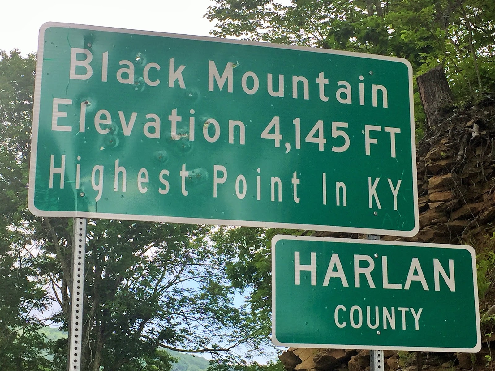
This mountain sits at the borders of Kentucky and Virginia.


Steve standing in both Kentucky and Virginia.

It starts out paved and is very green and lush. We heard there have been bears up here but we didn't see any.

Just this little guy.

First we passed this large tower with a strange dome on top. It looked like a huge soccer ball.

After a little hunting we found the High Point marker under the old, partially dismantled fire lookout.


Highest Point in Kentucky!

At least they had a little plaque up here for the High Point. Some places make a huge deal out of the High Point with fancy observation towers, some you practically drive right up to and when we're lucky, hiking is the only way to get there.


We never did find out the significance of the painted bicycles, but they as well as some bears, were all over town with cute painted designs, bright colors and flowers.


We found the little park that was home to the Coal Miners Memorial Wall. It was a nice park located near the old railroad tracks. The tracks are now a hike/bike trail that currently runs about 4 miles with plans to expand. We really liked the park and the memorial. When we checked we found there was no geocache here so we hid one. So if you happen to be near here, come look for it.


No water here now.

Just outside of Benham we passed the community of Scotia. There isn't really much here now but it is known for it's tragic past. One of the worst mine disasters in the US. This horrible event brought about much safer work environments for future miners.

Back at camp we pass the colorful Elk out front. Benham has it's bears and bikes and this area has Elk.


Time to get onto the water. Hurley loves to ride in the kayak! The day-use area just around the bend from the campground is just as well maintained and spotless.

The boat launch.

There were several people fishing from boats and on the shore. We cold even see the fish along the rock walls. Too bad we didn't have our poles.


Sometimes small towns were flooded to create many of these lakes. We noticed some old blacktop roads that ran under the water line. Sometimes you'd see roses and other flowers that look like they were once planted in front of someones house that used to be there.

We liked the large flat stones layered with the slate.

This was a strange, round boulder almost the size of a VW sitting at the edge of the water. It looked a lot like Steve's fancy new ice cube.


Sometimes the layers were very colorful with reds, pinks and blues.

The crazy growing Kudzu overtaking all the trees and bushes.
Follow us along next as we hit Kentucky's famous Bourbon Trail!
Great little find! Looks like a nice, peaceful place. Those small town museums are so informative. Too bad it was closed.
ReplyDeleteThey had a couple of nice places we'd have liked to peek into. Sometimes we seem to hit them on Mondays or the one day of the week they are closed.
DeleteWe say something similar: It isn't illegal unless you get caught. LOL
ReplyDeleteI like how you guys think ;-)
Delete