"Two roads diverged in a yellow wood... And sorry I could not travel both. I took the one less traveled by. And that has made all the difference." --Robert Frost

Saturday, October 8, 2016

Hiking in a Slot Canyon at Tent Rocks

Cochiti Pueblo, New Mexico
Lake Cochiti Campground


If you read our last blogpost, you know that we re-routed our trip back to Arizona so that we could stop in this area to hike the slot canyon Ingrid told me about.  It is a magical place. Thanks Ingird!

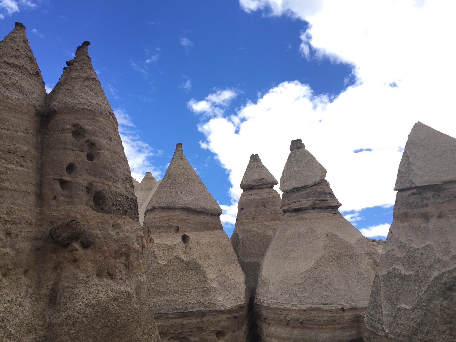
Kasha-Katuwe Tent Rocks National Monument is managed by the BLM and is about 40 miles SW of Santa Fe, NM.  Kasha-Katuwe means "white cliffs".  The area is made up of layers of volcanic rock and ash deposited from a volcanic explosion that occurred 6 to 7 million years ago. Over time, weathering and erosion of the layers created canyons and tent rocks. The tent rocks are cones of soft pumice and tuff beneath harder caprocks, and vary in height from a few feet to 90 feet.


The trail begins at the monument parking area. The Cave Loop Trail is 1.2 miles long and is easy. The more difficult Canyon Trail is a 3 mile round trip trek into a narrow canyon with a steep (630-ft) climb to the mesa top for excellent views of the Sangre de Cristo, Jemez, Sandia mountains and the Rio Grande Valley below.

Starting the trail. It's hard to imagine what's to come from here.

As you get close to the slot canyon portion of the trail, it's surprising to see these pine trees in the desert landscape.


Starting to enter the slot portion of the trail.

The walls get taller and much more narrow.

This is probably the narrowest part.


The colors of the cliff sides are just beautiful.  Ghost trees strangely balanced in the canyon.


You can see the dark caprocks that balance on top.


We had some crazy weather while on this hike.  Half the sky was very dark and if you looked the other way, sunny.


Looking straight up there was this pretty colored aura around the sun.


Now were getting to the steep part.  After the steps is a little bit of rock scrambling to continue on.

Good view of the different layers of rock.
 
View from the top of the canyon floor and tent rocks below.

And amazing 360 degree view from the top.

 
Steve and I having a little snack and enjoying the tent rocks.


Time to head back down.


Back through the slot canyon.


Crazy roots on this living pine.


We also took the side hike to the Cave Loop to make the hike 4.2 miles.

The black part on the ceiling is from fires.


It was fun to walk around these "tents" just sitting below the canyon.  How strange it must've been to come across these out in the middle of no where?


Sentinels on top of the ridge.

We also did the Veterans Memorial Trail which added another mile to todays outing. Gorgeous view again from this vantage point.

What a great place to see!  Being full time on the road allows us more time in areas we might have skipped over before.  We really like the lesser visited areas.  While there were very few people here, our next outing has us surrounded by many more people and lots of balloons! 
Guess where we'll be?


Saturday, October 1, 2016

Hello New Mexico

Cochiti Pueblo, New Mexico
Cochiti Lake Campground


Once again we pass through New Mexico.  This time I carved out some extra time so that we could visit a special place that Ingrid told me about.  And if Ingrid (of Live Laugh RV) says I need to do this hike, then I'm in!

It was a bit sad to say goodbye to those gorgeous mountains in Colorado but the snow was chasing us out.  As the calendar flips to the month of October, we find the landscape quickly flattens out and the temperatures started rising as we head south into New Mexico.

It does have its own beauty though.  You can see what seems like forever.


The colors in these mesas were very colorful.  Pinks, grays and bluish purples.


Our destination for the week was Cochiti Lake.  The campground lies within the Pueblo de Cochiti Indian Reservation.  The Cochiti Dam is one of the ten largest earth-filled dams in the United States, and also one of the largest in the world. There are 80 campsites, 48 with electric.  Most were very spacious and level.  Since the temps were not too warm, we chose a non-electric site very near the water.  It was elevated and surrounded by a wrought iron fence.  A little weird at first, but I kind of liked it.  We had high hopes for some evening kayaking.  Unfortunately, this time of year the winds kick up in the afternoons so Big Red never left the top of the truck.
 
Loved our site, #78.

We had a little visitor welcome us.


The price for non-electric was $12, $20 for electric.  There are several central water spigots in each loop.  If you choose a site next to one you could fill your tank from your site with a decently long hose.  There are dump stations, marina, lookout and hiking trails.

We didn't get out on the water, but we had fun driving the back roads along and up on the surrounding mesas.  We chose an interesting string of caches representing geo-art.  In this case, an arrowhead to represent the arrowheads found in the area from long ago. If viewed from a satellite or on the geocaching map, you can see the shape of the arrowhead.  This particular group of caches were titled, Bajada Arrowhead 1 - 18.  And no, we didn't find any actual arrowheads.

It took us about 2 hours to drive/hike to each of the individual caches scattered about the desert mesa.  It was very windy and not much to look at most of the time.  But every now and then there was a surprise.

 
We came upon the remains of a long ago dead cow.  It seemed to be eerily smiling at us.

Then there was this other form of art that had a hidden cache on it.

And another at a monument.

 
After all that caching, off we went in search of a drink and a snack.  We stopped in (at different days) at the Blue Corn Café & Brewery and the Santa Fe Brewery, both in Santa Fe.  Steve didn't care for the Blue Corn Brewery but he did like the Happy Camper IPA and their double IPA at Santa Fe.
 
We also drove through some of the small eclectic towns such as Cerillos and Madrid.  Their populations are around 200 and 150 for Madrid. We stopped in a little museum and gift shop with a petting zoo outside.


The artsy town of Madrid.


We had intended to drop off quite a few Geocaching "trackables", but actually found quite a few.

While driving part of the Turquoise Trail from Santa Fe to Albuquerque, we found many other Geocaching Series.  This one in particular was put together by a family and had some of the most amazing cache "containers".  Usually they had clever animal names and were handmade into animal shapes.  There were hundreds and it would've taken days to complete them all.  We set a new high record for us, completing 84 in one day.
 
Next Up:
Hiking at the awesome Kasha-Katuwe Tent Rocks National Monument!