Placerville, CA
Elks Lodge
Elks Lodge
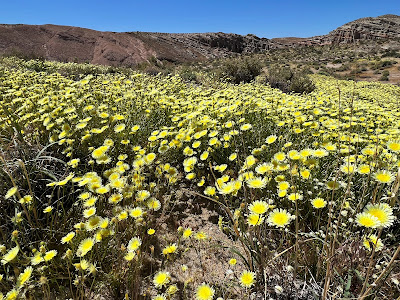
This lovely flowering desert is Red Rock Canyon State Park. Before we get here though, we had to visit some of our friends back in Placerville.


Our usual favorites, Carnitas for Steve and Carne Asada for me.
Another meal with Jim and Jenny for beer and pizza and to swap some camping stories before we head south to the desert for some warmth during this unusual cold spell.
Merced, CA
Elks Lodge
This is a favorite stop off Hwy 99 when heading to southern CA. They have a very nice campground, with water, electric and dump. $25.Sites are level, decently spaced and offer some shade. It's a quiet spot surrounded by farmland.
Fresno, CAElks Lodge
Steve had a busy work week and since we wanted to get a jump on the weekend it meant some shorter stops along the way. This Elks is also nice with water, electric and dump. Nice shady spots on grass.

Cantil, CA
Jawbone Canyon, BLM
It was a three hour drive as pulled into Jawbone Canyon. This is dispersed camping on BLM land. It is popular with off-roaders, especially on weekends. We arrived on Sunday. No one here. The coordinates to this spot are: 35.30911N 118.01452W, elevation 2238.
The canyon gets much more colorful the further back you go, but cell signal disappears. We stopped near the pipes where the signal was still strong. What are these huge pipes? It is part of the LA Aqueduct pipeline which gets its water from the Owens Lake. It is 233 miles long and entirely gravity fed. No pumping stations. The deepest plunge along the way is here in Jawbone Canyon in the western part of the Mojave Desert. The pipe in this section is more than an inch thick to be able to handle the pressure. It was built in 1913. The project was completed on time and under budget by William Mulholland. He was adored by the people of Los Angeles, but hated by the people of the Owens Valley, whom he cheated out of their land.That is the water pipe in the distance behind our rig.

We're here to visit Red Rock Canyon State Park and do some hiking.
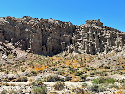
This area was once privately owned by a German immigrant who used it for mining claims. He gave tours of the area and named some of the rock formations. It later became a state park in 1969 after his death. This entire area was once at the bottom of a lake 10 million years ago. Sediment washed down the mountains and was deposited in layers. Time and pressure turned the layers of sand and mud into huge rock beds. Due to tectonic movement, the floor uplifted and the lake dried up. Wind and water erosion created the formations that are throughout the park. The bright red color is due to high iron content in some layers. Water trickles down from rainfall and makes it looks like the cliffs are bleeding.
Not only were we impressed with the colors, we thought we had missed most of the bloom. We were wrong. It was peak season here in the park!The Desert Dandelion covered the desert floor as we walked to the trailhead.
We took the Hagen Canyon Nature Trail. This was an easy trail maybe 1 1/2 miles. You'll do more than that though climbing up and around the cliffs.
The red capstones sit atop the softer gray sandstone that washes away over time.
We saw plenty of lizards and birds darting about.
The purple-blue Psorothamnus stood out among all the yellow.
You walked along the sandstone and sandy washes.
A brightly colored Blue Belly Lizard.
These formations were lifted to a 17 degree angle.
The Yucca were still blooming as well.
We just couldn't get over the beauty out here.
After our hike we drove over to the campground in the park to check it out.
There weren't many people camped here. I'd love to hear the stories of the people that own rigs like these. Must have interesting travels. Lots of money right here.
Here's what one of the sites looks like. It's a small campground but nicely spread out. No utilities. Just bathrooms. I's $20. The only water is at the Visitor Center. Best to bring your own. It also gets very windy out here.
Bright red Indian Paintbrush.
We then tried to take one of the off roads to investigate more but it's mostly off road use and too narrow and the sand too soft and deep so we didn't go far. The pretty stuff is back at the park anyway.Most of the state park is on the NW side of Red Rock/Randsburg Rd. Across the street is another smaller area with some more beautiful walls of the red stuff. There is a longer hiking trail that wraps around it but it was pretty hot and very windy by this point, so we decided to save it for later if we had extra time.
If you haven't been here it's worth a stop. A couple of days would cover it unless you wanted to do some off-roading. We have a couple of more things to do in this area before we leave.


That’s a great looking area. We always blast thru Mojave and Tehachapi so will put this park on our list. Safe travels!
ReplyDeleteMohave area has some great camping and fun slots and hikes!
Delete