Roosevelt National Park
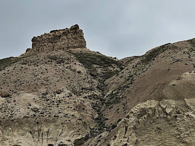
Ever wonder what the highest point in North Dakota is? While most people think of North Dakota as flat, you might be surprised to find out that White Butte is 3506 feet above sea level.
A drive past Amidon and down a few dirt roads through miles of farmland and you come to a sign just off the road for the trailhead. The trail is 4 miles but you have to park and hike one mile to get to the trailhead itself. Both the parking, trail and high point are on private property owned by the Dennis Family. It's always nice when this happens and the owners allow you access.
It had rained the day before and it was threatening to rain this morning. It was also very cold and windy. This area is known for muddy conditions and soil that absorbs water and is very sticky and slippery. It was our last day in North Dakota and we weren't going to skip it. I even got my brother to come along.
That's White Butte in the far distance. It was a bit tricky to walk and stay out of the mud. We were wet up to our knees with the wet grass in about 10 minutes.
We passed an old homestead along the way.
Getting closer.
After dodging the mud puddles for a mile in the cold, we reach the trailhead. It's nice they had signs posted for the parking and the trailhead. There was some flooding here so we had to find a spot to crawl under the barbed wire to get to the trail.
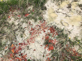
There was this really cool red soil spread out that looked like broken clay pots.
A close up with raindrops still hanging on.
We soon find ourselves in some small canyons and we are protected against the wind for now.
The spring flowers are starting to pop here. You can see why it's called White Butte. The soil looks like sand but it is very sticky.
We had to be very careful. It looked fine, but some spots would suck you down and you'd slip and slide trying to get out.
At this steep part we weren't sure if we'd make it up the slope.


Lots of blue and purple.
Some strange looking blobs of rock.
We thought this might be the high point but it turned out not to be.
This is the actual high point up beyond the trees and grass.
Looking around the peak, the other side was more green and had more trees.
That grassy area just before the brown, mowed fields is where we are parked.
We pass some rocks with colorful lichen on them.
The last part of the trail straight up to the top.
Finally here we are!
A couple of things stand out here. Usually the benchmark is cemented in the rock or soil. You'll notice in the picture above the marker is about 2 feet from the ground. This is due to rapid soil erosion. Pretty amazing how much has eroded since 1962 when it was placed.
There is also a geocache here (that's the ammo can chained to the marker.) Lastly, see that small plaque behind the top of the marker? It's one of those plaques placed at graves in cemeteries.
Of course I'm curious as to who Lawrence is and why he is buried(?) up there. When I got home I googled it and found it's a memorial tribute to the former property owner. He is buried at a nearby cemetery. We did find some bones next to it but they must be an animal and thankfully not from Lawrence.
We added a rock to the top of the cairn pile for someone else to take.
After a selfie at the top and a snack we headed back down.
A few quick pics looking the other directions.
High Point #30 for us!
Looks like someone else had a problem with that slippery mud too and had to put there hands down so they didn't fall.
We walked over to the old house for a look around.
Not much to see. There was a bunch of old broken bottles, magazines, etc at the base of the walls.
Almost back. My brother looked down and saw this nest of ants. They were moving in a boil kind of movement. Very strange looking.
We were so glad the weather held out for us. The clouds thinned out making for a very nice sunset. We took one more walk around the campground and watched the buffalo grazing about and not caring one bit that we were nearby.
They were walking right past a bunch of tents.
We had a great time in North Dakota and we were happy to visit our last state in the Lower 48!


