Bryce Canyon National Park
The nights are cold, sometimes in the 20s but we got lucky with warm days. Well, 50's warm. We drove the main drive through the park and while many of the side roads were still closed due to snow, some were open.
Our first view. I was really excited to see snow here. It was July, 20 years ago, when we were last here and winter brings a totally different view.
There are many amazing hikes and sites in Utah's parks, but to me, nothing can compare to the colors of Bryce. Orange, Pinks, reds, greens and that deep blue sky!
The famous Hoo Doo's!
An old, dead, bleached tree. Still majestic.
Lee and Trace
The sun coming and going behind clouds would cast bright colors here and there.
We took a drive out to Bryce point.
Steve has a twin. Who knew?!
Hurley loves to catch snowballs!


The famous Natural Bridge, 8627 feet elevation.
We still had plenty of time left in the day so we took a small hike to Mossy Cave.
The scenery was fabulous as soon as you parked and started the hike.


Pussywillow's starting to bloom.
A pretty waterfall that looked like chocolate milk.
Veni, Vidi, Vici!
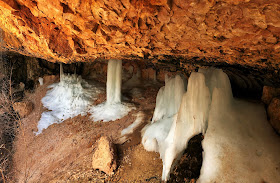
This part of the trail leads to a waterfall that flows over Mossy Cave. While it may be mossy in the summer, it has ice formations under it where the water seeps and freezes. Very, very cool!"This grotto forms as un underground spring permeates the bedrock and water slowly dissolves the calcite and muds of the Claron Formation. During the short spring and summer season, in the otherwise arid landscape, a cool, moist environment becomes a perfect place for mosses to grow. By late fall, icicles begin to form from as water continues to seep through the rock. Sheltered from the sun, even as the days are growing warmer and longer these icicles sometimes last until June!"
A single dead leaf hanging on.
Lots of windows and arches.
Then we took the trail further to a really pretty waterfall where the colors reminded me of Neapolitan Ice Cream. Strawberry, Chocolate and Vanilla colors.
We had more time in our day since the snow had kept us off some of the viewpoints so we decided to drive to Cedar Breaks National Monument. We weren't sure if it would be open but we're up for the drive. Well, we forget the elevation is closer to 10,000 feet and there is still several feet of snow.
The Aspen were sparkly white against the pines. It was 39 degrees up here.
So I guess it shouldn't have been a surprise when suddenly the turn off just ends. No more plowed road. The park is close obviously. Still about 4 feet of snow. Oh well, it was a pretty drive.
On the way back I took a picture of this cute hillside where all the roofs were very colorful.
Next we hike the Fairlyland Trail. One of the few not totally covered in snow.


That's such a beautiful area. I think Utah is our favorite state for hiking!
ReplyDeletewww.travelwithkevinandruth.com
It is. We'd like to get back in warmer weather for more hiking down the canyon. Still a few hikes we haven't done yet.
DeleteGreat pics! Nice to see what it looks like with a little snow. By far our most favourite park to date. Safe travels!
ReplyDeleteI've always wanted to be there with a little snow. That worked out perfect. It was just brutally cold at night and a couple days.
DeleteWhat an awesome area, Deb! Also, thanks for the tip on the commenting. You were correct! It works on the computer, but not on the mobile devices.
ReplyDeleteGlad you figured it out. I'm not sure why that is with the mobile though?
DeleteSo much color in the hills and hoodoos! I love your cheesy picture <3
ReplyDeleteThanks Rene! The colors here are my favorite!
DeleteBeautiful year round but the addition of snow makes it incredible! You certainly got some great photos to capture your memories.
ReplyDeleteThanks. Looking forward to some fishing!
DeleteI'll just enjoy the snow pictures thru your blog, all it's appeal has gone away after so many years in VT. Is there an app you use to find the benchmarks?
ReplyDeleteEven after living in Lake Affect Snow Country in Upstate NY, I still like a little snow now and then. Glad I don't live in it anymore though! There is a benchmark sub-program having something to do with Geocaching but it's hard for me to remember it. We hardly do that anymore but it will take you to SO many historic buildings as well as peaks. Most elevations/trails/lookouts will have at least one type of marker on it if you look. Rubbing the high peak marker is something I've done since I was young. For good luck. Veni, Vidi, Vici!!
Delete