Cabela's RV Park
-------------------
Kimball, Nebraska
Oliver's State Park
On our last post we were leaving Kansas heading to Nebraska. We'd have to cut through the very far NE corner of Colorado to get there though. We were staying as far east as we could to avoid the storm that was currently hitting Denver.
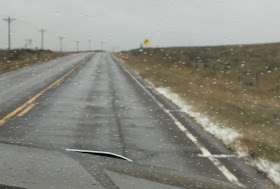
More sorghum and farms dot the wide open plains. As I kept close check on the weather app I could see that we'd be most likely driving through some of the snow as it crossed by us.
Luckily it wasn't too bad.
It didn't take too long and we were back in Nebraska. The panhandle this time. Wyoming was just to our west and Colorado to our south. We didn't want to drive though the snow any more than we had to so we spent the night at the Cabela's in Sidney. It is the headquarters and probably where most of the people that live around here work.
There were a few spots open and most of the snow had melted. We had water and electric. There was a little confusion on how to check in. You are supposed to check in at the store first and they assign you a spot. You pay there but fill out the envelope at the campground. We got a Good Sam discount which was nice but since the water wasn't working we were supposed to get a discounted price to begin with. For some reason this caused much confusion on how to ring things up. We gave up and just took the Good Sam discount making it $25 a night.
We left early in the morning for the 45 minute drive to Oliver's State Park Rec Area. There used to be 4 campgrounds here but after a water dispute the lake levels dropped and most were closed. I was expecting a dry lake. Not only were we surprised that there was water in the lake, there were several trees around in beautiful fall color, AND, the campground was free since it was off-season.
We chose a large site that had a great view of the lake. There was only one other person here several sites away.View from the lake looking back up at our site. Love the huge, colorful trees! It's been pretty flat and not many trees around for quite awhile.
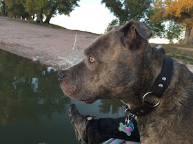
The pooch and I walked around the lake and investigated while Steve worked.
Steve had a day off and we had a lot planned. It was about an hours drive down many dirt roads that once again zig-zagged through long stretches of mostly plowed farm land. There are also some cattle.
We wondered if the high point for Nebraska would be on a plateau like these (nope).
Lucky for us the roads were in good shape and before we knew it we were there. This high point sits on a privately owned ranch as do a few others. It's nice to see that these owners do their best to keep access available to the public. This ranch raises bison. It's the first one we've come across that charges an entry fee. We were happy to pay the $3. The owners state that this is to help cover the expense of the gravel they put down to make access easier. Since you are driving through the bison area you are not allowed to walk. Driving only and it's a couple miles to reach. Unless the mostly dirt road is dry you will need 4 wheel drive to get through the soft muddy ground.

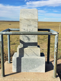
You can see for miles all around. There in the corner sits the lonely marker surrounded by pipe so the buffalo don't knock it over.
The buffalo stayed far away from us.
What a view!
No street signs or anything else, just this. Since there really aren't many roads to speak of, it was pretty easy. We passed some buffalo in a pen and a few more ranches.
It's a looooong way to the grocery store or gas station for these folks.
Once again you have to enter through private property. At first we weren't too sure if we could drive through or would have to walk. There wasn't too clear of a road, but nothing out here so we decided to drive after opening then closing the gate.
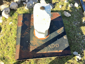
After a short drive following the fence line we came upon the Tri State Marker where Nebraska, Wyoming and Colorado all come together in a huge pasture. After reading the info and finding some geocaches we looked around and thought how lucky we were to be here. I'll bet almost no one comes out here. I thought that was pretty cool.
Wyoming/Colorado/Nebraska est. 1869.
Veni, Vidi, Vici.
The fence line between Wyoming and Colorado with Nebraska's fence line in the background.
As we were driving out you could see some small buildings that seemed very out of place out here. There was a helicopter buzzing above us. That also seemed strange.
After driving back through the gate and closing it, just down the road a bit we saw this. Maybe you can't tell, but those are machine guns mounted on the military vehicles. They were leaving a heavily fenced area that contained a few very old barn/sheds. We later saw what could be hidden bunkers or other things that the government/military must want to remain hidden. I don't know what they are, but I guess way out here with nothing but the buffalo and a couple of marker seekers would be a good place to hide it!
Once back near the town of Cheyenne, WY, we stopped to see this large statue that we passed while on the way to the high point.


Once back at camp we walked around the lake some more and let Hurley have some fun in the water.
And he sure did. He splashed around for a long time.
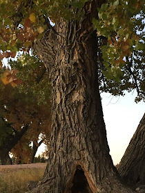
While walking around we noticed a large notch missing out of one of the large trees. It looked like a home for a gnome or something. Then we stepped back and looked again. Just above the notch was what looked like a wolf's head in the bark. Do you see it?
We sat on the little dock and watched the sun going down.
We really enjoyed our months driving through those "fly over" states of the Midwest. Some people wondered why we wanted to spend our time here. Well, it turned out that there was as much to do and see as we thought there would be besides the high points. And really, there was so much more that we wanted to see but as usual, there isn't enough time for all of it.
We will be spending a few days back in Colorado visiting our friends Greg & Cori before heading to Arizona to be with family. I know Colorado is still quite a ways away from California, but somehow it feels close to home and that we are ending this years trip. While that always seems a little sad, I have been missing the mountains very much.











Love this post. Great campground. Loved the wolf face and the heart picture of the water. WHAT no more high places?? I will look for why in the next post!
ReplyDeleteThe campground was a nice surprise as some info said it might be permanently closed. I'll give you a hint on why we didn't get the other high point, "Bzzzzz" :-(
DeleteThanks Trace. Might not get the answer until after the Colorado post ;-)
DeleteWho knew all of that was out there to be discovered??!! Thanks for sharing :-)
ReplyDeleteRight? We love stuff like that!
DeleteIt's amazing what one can find in the middle of nowhere. Great campsite too!
ReplyDeleteSafe travels!
Thanks! Sometimes the middle of nowhere is the best place to be!
DeleteYou sure did find some great campgrounds going through the Midwest.
ReplyDeleteIt was a good time!
Delete