Friday, June 30, 2017

Country Roads - West Virginia

Lewisburg, West Virginia
Lewisburg Fairgrounds


Take me home, country roads... John Denver had it right!  Steve's family is from the tiny town of Ronceverte, WV, population 1753.  We hadn't been here to visit for many years so we were looking forward to our time here.  Most of his family moved to Virginia over the years but he still has a dear aunt and some cousins here. 

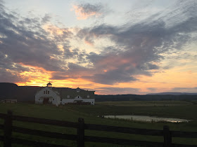
Many farms on rolling hillsides.

Our drive from Kentucky and through the lower part of Virginia was short and uneventful.
Always a surprise to look up and see this on the freeway.
 

This week we'd be settled in at the fairgrounds in neighboring Lewisburg.  This is where the State Fair is held.  They have thousands of campsites!  Since there was only a couple of us here, we had plenty of space.  We chose a spot near the front because it had a couple of trees for shade.  It was very hot and humid!  We haven't really had much of that up to this point.
Full hookups, $27.  We were lucky as the Greenbrier Classic PGA Tournament was going on at the nearby ritzy Greenbrier the following week and the fairgrounds would be packed.  They also jack the prices up to $50 a night. 
 
 
The Greenbrier is a National Historic Landmark and world-class resort since 1778.  For over 235 years, the natural mineral springs have brought visitors here including 26 Presidents.  It is a gorgeous place!  We've only seen it.  Steve's cousin, Aaron, works here and invited us to come have lunch. Well, they have a very strict dress code of resort/formal attire.  NO denim of any kind.  Well, that counts us out!  Maybe another time.
There are tours offered of the declassified Bunker at The Greenbrier. It takes you behind the scenes and walks you through a deep, carved path into the mountainside.  Beneath the West Virginia Wing is an emergency Cold War fallout shelter which was once a top secret U.S. government relocation facility for Congress. The tours are $34 each.  We haven't done this yet but would like to.
 
We spent a day in Ronceverte so Steve could drive down memory lane once again. Ronceverte is a railroad town.  Part of the C&O lines that connected Pocahontas County to Hinton, and to Clifton Forge, Virginia. Ronceverte was part of the "Gravel Girtie" line where train cars were sent to the limestone quarry at Fort Spring and loaded with crushed lime. During World War II the lines carried German prisoners of war.  Many of his family members worked for the railroad or in the nearby coal mines.  --Update-- I received info from family members that the crushed limestone came from a quarry in Snowflake, not Fort Springs.  I got the info from the train station in Ronceverte.  When I did more research I found some of the time it referred to Snowflake and other times it was Fort Smith.  Both towns are located very close together.

Steve's great grandfather once owned the hardware store in town.  You can barely make it out anymore painted on the red brick.
Lee & Son Hdwe, Inc.
 
Not much to this town anymore, but like many others, there is a revitalization going on.
 
We visited the cemetery and brought fresh flowers.


We also drove to his grandparents property.  Much of the land has been sold off over the years and the old homestead burned down several years ago.  It is very overgrown now.

This is the old drive.  Too thick to even walk through.

Still some pretty old buildings and homes along the river.

The Greenbrier River.

There are a few covered bridges in the area too.

Big, beautiful farms and horse ranches.
 
I do love to hear his stories of spending summers at his grandparents.  Pointing out where they used to play, get ice cream, swim and get into trouble.  Remember how some things "back then" seemed bigger?  He was surprised when he showed me a place they called Hamburger Hill that they used to run up and down.  Well, it's really more like a 10 foot dirt embankment!  We had a good laugh over that one.
 
Ever hear of Salt Rising Bread?  Me neither until I met Steve.  It is a dense white bread that was widely made by early settlers in the Appalachian Mountains, It is leavened by naturally occurring bacteria rather than by yeast. Salt Rising bread is made from a starter of potatoes instead of sourdough starter.  Rotted potatoes. The bread starter requires a shorter incubation period and a higher incubation temperature.  The bread has a distinctive taste and odor. The pungent odor of the starter has been described as similar to "very ripe cheese".  Not to be insulting, but to me it smells like vomit.  And when it's in the toaster, whew, look out!

So my mission while Steve was working was to find one of the few bakeries around that still makes it.  It involved an hour drive down a windy road that took me through even smaller towns.  It was a beautiful drive.  One particular town caught my eye and I parked and walked about a little.  The town of Union had a monument behind the cemetery that needed investigating.  I love walking around old cemeteries and this one also had a geocache hidden there.  Bonus!
I read about the Confederate monument and the battles that took place here as well as many amputations.  I also found the cache hidden cleverly in the far corner under a tree.  It was a log made out of Styrofoam and painted perfectly.  I would've like to have spent more time here but I was on a mission to get 4 loaves of the stinky stuff they were holding for me before they closed.


The scenery was so pretty and the Antebellum style homes were everywhere.  Reminded me of Gone with the Wind.  I did get to the bakery and bought the 4 loaves of bread.  Across the street was an Amish Store.  I bought a big slice of Parmesan cheese which I mostly ate on the way home.  It was pretty good!
 
My week was filled with visiting the Historical Society to see if I could find any new genealogy on Steve's family.  There wasn't anything new I hadn't seen in previous years so I spent most of the time chatting with some older gentlemen that seemed to know many of Steve's relatives from long ago. 
 
After dinner we cached a little more and discovered there is a component to Geocaching called Benchmarking.  Not sure exactly how it works yet, but it involves locating benchmarks that are usually on old, historic buildings or places.  This one was on the Post Office.  1961 isn't that old, but it was fun finding it.  We may look more into this, but regular 'ol Geocaching keeps us busy enough.

Of course we had to pop into the Greenbrier Valley Brewing Co.  Steve sampled a few, but wasn't all that impressed.

The beer wasn't so impressive but the brewery itself was.

Last but not least, our main reason for visiting was to see Bob and Sally.  We call her Aunt Sally.  While she isn't actually related, she was raised with his Mom and they were closer than sisters.  We are very fond of her.  Being with her is like being with a little piece of his Mom (who passed serveral years ago. )
Steve, Sally & Bob.

 
We visited with them a few times while we were there.  On our last day we went to their house and Aunt Sally made us a wonderful home cooked Pot Roast meal with all the fixins'.  It was so good!
 
 
They have a beautiful home and we enjoyed a lot of Front Porch Sittin'.


Later that night we were able to meet up for a drink with one of Steve's cousins, Aaron. He's the one that works at the beautiful Greenbrier Resort.  We were very thankful to them for spending time with us so late at night as they both are crazy at work with the PGA about to go on.
Aaron, Susan and their son.
Thank you Susan for the jars of pickles.  They are delicious!
 
Next up: More family time in Virginia and a Class Reunion.


Thursday, June 29, 2017

Mt. Rogers Hike - Highest Point in Virginia

Cumberland Gap National Park
Wheeler, VA
-------------------------------------
Grindstone National Forest Campground
Marion, VA


A 3 hour drive brought us from Kentucky to Cumberland Gap, Virginia where we decided to stay a couple of nights to break up the drive.  Before we arrived we stopped at a gas station and were amazed at the tow truck that pulled up next to us. 

Not only was it huge, but it was spotless!  Clean and shiny as any fire truck.

This is who you call when your 18-wheeler needs a tow.

Driving through the Cumberland Gap Tunnel, you are very near the borders of Kentucky, Tennessee and Virginia.  It's a fairly new tunnel that opened in 1996.

 
What we learned about the Cumberland Gap is that it is a natural "gap" in the Appalachian Mountains where Daniel Boone led many people through to settle on the western side.  He did as the Indians did, they followed the buffalo to find this way through the mountains.  I didn't know there were buffalo this far east. 
 
 
The National Park campground is fairly small and very wooded.  The Verizon service was pretty good but only in some sections.  There was electric only at $20 a night.  Most sites are on the smaller side and many are not very level.  We barley fit in one of the few spots left.  Since it rained the whole time we were here we enjoyed some quiet time and a movie in town.  We saw Wonder Woman and it was much better than we expected.  The theater was very old and really needed updating.

#C23.

Our little yard that we never used.

Time to move over to Grindstone National Forest Campground near the town of Marion.  Once we set up we took a little drive to a hidden spot not far from our campground.  A beautiful little waterfall that we only knew about because there was a geocache hidden here.  What a great spot!
 
This campground is very wooded.  $32 a night, W/E.  Pretty expensive for a National Forest campground but since the Appalachian Trail runs right by it I guess it can be a busy place.  Cell is non-existent here.  Plenty of long, level spots.  We have been very lucky so far that there have been little to no mosquitos on our trip this year so we've eaten outside more than we normally do.
 #57

We had some great fires.

Big, beautiful campsites.  Plenty to choose from.

Our first hike was a short one up part of the Appalachian Trail that winds through this area.  There was a geocache hidden nearby.  At first we wondered what all the "tape" was spread through the woods. Then as we got closer we recognized it as sap lines that are used to gather the sap from the Maple trees to make maple syrup.  There is a short time when the sap runs in the spring. Buckets are hung from the black plastic taps.


There was this old wooden church that we passed coming and going to the campground.  I had to stop and take a picture.  Not too much info about it but apparently the original had been vandalized and burned.  The locals got together and rebuilt the church in 1945. The craftsmanship is amazing. The
doors are kept open to anyone who wants to stop by.

 
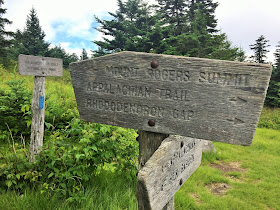
Our big hike the next day was to the top of Mt. Rogers, Virginia's highest peak.  We were really looking forward to this one as this would be our longest hike so far.  It's 9 miles round trip.  It is rated as difficult, but we found it to be moderate.  There were a few spots of rock scrambling, but for the most part it was more average.  Just a longer hike.  Part of it is on the Appalachian Trail.  There is a lot of variety here.  You hike through 4 distinct areas: open grassy areas, rocky outcrops, woods and a boggy spruce forest at the peak.
We started out at Massie Gap hiking at the Rhododendron Trailhead. 

Should be a very nice hike weather-wise.  Just cooler with some fog at the very top.

There are several trails that criss-cross this area and they are very well marked.

The other exciting thing about this trail is that there are wild ponies in the area and you will usually spot them on the grassy highlands.  In the summer there are Longhorn cattle that roam here too.

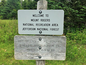
Pony hair on the sign.  Hopefully we'll see some!

The Rhododendron part of the trail starts out with many blooms.  The Rhododendron had just finished blooming but the Mountain Laurel was showing off. 

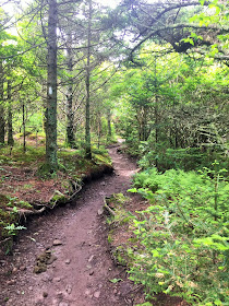
The trail was very smooth in most sections.  There were some crazy roots to maneuver here.

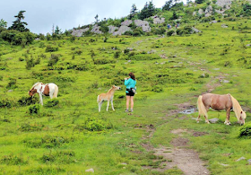
As we left the woods and entered the first grassy knoll, there they were!  And with little babies!

They were so cute!  They are very accustomed to hikers and will pretty much ignore you as you hike by.  Signs warn you not to pet or feed them as they want to keep them wild and self sufficient.  The babies never bothered to even get up.  They were enjoying the warm sunshine. 

Snoozing on the trail.

After the first half mile you leave the Rhododendron Trail and follow the Appalachian for most of the rest of the way.  At about a mile and a half in the trail becomes more rocky and rugged. 

An interesting heart shape in the rock.

We left the blue blazes and are now following the white AT blazes.

Notice the white blaze on the tree?

We'll be hiking over and past this peak.


Leaving the State Park boundary and entering the National Forest.

There is a horse camp here.  It's a very popular area and while horses are not allowed on the AT, there are several other trails here where they are.

The ponies and cattle keep the grassy areas looking like a golf course in some places.

Some climbing and rock scrambling along this section.

When you get on top of some of the rocky outcroppings the views go on forever!  I'm sure the colors of fall must be amazing from up here.

More ponies.  We watch the weather constantly change as the clouds come and go quickly. 

 
Cloudy, then in minutes, sunny again.


The fog and clouds were blowing fast and cold up here.
 
 
Once you get into the forest it's really pretty and the area is full of large rock piles to climb around, over and through.


This pile had a tunnel to crawl through.


The other end.
 
My turn.


When I stopped to take a picture of these two, the baby walked right up to me.  He was very curious about my iPhone.  You are not allowed to pet them and they encourage you to shoo them away if they get close so that they don't get too used to humans. I felt bad scaring him away.


Once we climbed over this rock saddle, we could see and hear the Longhorns although I couldn't get close enough for a decent picture.

That's Mt. Rogers I the far distance.

Getting closer.  We're a little more than half way.


After cresting another peak, and a lot of muddy trail, we see the shelter.

The Thomas Knob Shelter is a popular spot for through hikers.
 
You soon leave the gated/fenced Knob area and enter the Lewis Fork Wilderness.


You can see the summit in the distance now but only for a short time.  We leave the Appalachian and take the Mr. Rogers Spur Trail for the last half mile.  Now you are entering where the spruce and fir grow.  It's colder up here and very boggy with a sweet smell.  There are ferns and a thick coat of moss grows on everything.


After the short climb you reach the top.  No views through the trees from up here though.

    
There are two markers.  The one above on the right is the actual high point marker.  The other (with the arrow) points to where the high point is and actually looks a little higher when you're standing on the large rock outcrop.  Not sure why they thought they needed the directional marker.  We ate a quick lunch, talked to another couple that was there and then headed down as it was cold and windy up top after grabbing a quick geocache.

Back down, through the gates dodging all the mud.

Once again we see the Longhorns.  This was as close as we got to them.  We didn't take any more pictures as we just enjoyed the rest of the hike down and stopped to take in the views now and then.

Once back at the bottom we spotted the "Regal One".  This pretty gray has a long thick mane and tale and appears in most of the parks advertising.  The hike took us about 6 hours total.  What a great day!  One of our favorite hikes this year so far.

 So true :-)