East Fork NF Campground
We took some great drives and hikes this week. One of my favorites was north of Pagosa where the Piedra Trail and some others are. There are also many waterfalls in the area.

The Aspen aren't leafed out here yet, but it was so green and the dandelions were so abundant. I know most people sure don't want them in their lawn, but here, the yellow was such a happy sight.

Williams Creek Reservoir. We watched the eagles soar above. There are some very nice forest service campgrounds around this lake.


A nice little hike takes us to Piedra Falls. You can only get so close without getting soaked by the spray coming off these falls as the water comes down with such force!


Beautiful views everywhere. You could drive around these dirt roads for days.
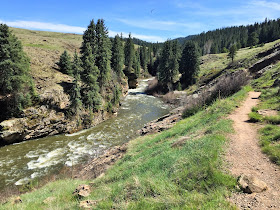
I was looking forward to doing the Piedra Trail. It's an 11 mile, easy trail. It starts out at 8240' elevation and has about a 1200' gain. A great way to hike at a higher elevation without a huge gain.
Steve and Hurley leading the way. It's a beautiful trail that starts in an Aspen and Fir groves. It follows the Piedra River.
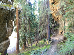
It quickly narrows and takes you through an amazing rock box canyon.
Crazy shaped rocks and boulders.
I like the pine tree growing on the pointy edge of the cliff.
It then opens up and takes you through meadow after meadow.
A snake Hurley found.
Beautiful flower covered meadows.
We loved this hike!
We were expecting to see Elk, but didn't see much wildlife. Hurley found something stinky to roll in and he had to get a cold bath in the river afterwards!
Steve doing a Yoga pose for our RV friend, Pam! Not bad, eh?
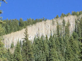
Ghostly Aspen among the pines and firs.


This is also a popular place to rock climb. On our way back we watched these two for a bit.
A great day on the trail. Time to get back and have some dinner.
These two pooches were enjoying their ride in the truck.
You start at the Visitor Cabin at 6,600 feet elevation. Walking tours begin in the upper lot at 7,400 feet elevation. Guided walking tours end at the Great House Pueblo at 7,600 feet elevation. We did both. So much information on how these structures came to be, what they were used for, who used them and what happened to them.
See that flat spot at the very top. That's where we're headed.
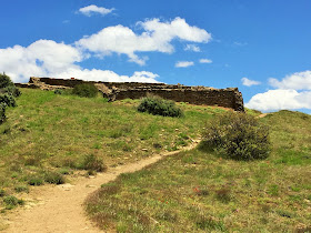
This is what it looks like as you get closer. Nice hike.
Great 360 degree views from up here.
An 80 million year old worm fossil.
A wealthy ranch owner owns much of this property you see.
Nice, huh?
The way they layer the rock and how precise they are is amazing. On the left is the more modern way compared to the haphazard way on the right.
Quite impressive!
The pit house at the very top sits with an amazing view. They are still not sure if it was for security or they used it for special ceremonies. Or both. It is said that they can light a fire here and it can be seen for hundreds of miles away. Sort of like an invitation. Other tribes do the same and it becomes quite the party.
Just beyond are the chimney spires. You are not allowed any further. They have nesting Golden Eagles and don't want them disturbed.
Found a heart in the bark of a tree. Sometimes I find them in rock shapes or cactus.
A drive to the pass and another hike to a waterfall.
Treasure Falls is right along Hwy 160. A short but steep hike takes you to some nice viewing platforms.
Wolf Creek Pass at 10,857' elevation, has some fantastic views from a short hike off the observation area. The entire valley opens up.
At the top of the pass you come upon the Continental Divide once again. There is still plenty of snow and some lakes are still iced over. We keep making plans to do some higher elevation hikes to get us accustomed to the thinner are to build ourselves up for summiting a 14er later. Problem is, once you get up that high the roads are impassable and the trails heavy with snow. Duh.
Avalanches are such a problem here, they have barriers for special sections of the road. Look how thick they are! That a serious barrier.
Now this was very interesting. On the way back down the Pass we were curious about these vehicles that were backed right up to the edge of a cliff. This was a huge pull out and no one else was there. So why are they parked like that?
Notice the rope tied on the bumper going over the edge?
Straight down!
We talked to the crazy guys at the bottom once they came back up. They actually take those kayaks down on their backs, all wetsuited up, down over the edge!
Apparently there is a tiny stretch of river after it comes down a fall that they all look forward to riding when the water level is just right. It is a crazy amount of work to get down there. Then it took them quite a while to get into the kayak as the water is raging. It was a very short ride then out they came and hiked back up a little bit further down. CRAZY! I don't think I could hike up that steep section let alone carrying a kayak and gear all while wearing a wetsuit!
And back up they came.
Our time in Pagosa Springs is over and we're headed to Salida with a quick stop over.


Loving all your CO posts, will have to use them as a reference when we spend time there, between you and Ingrid I think we'll find some real treasures in CO one day.
ReplyDeleteThanks and likewise I look forward to your Alaska trek! I loved your wildflower pic that I think you guys posted in Maroon Belles area? I'm really looking forward to Silverton and Ouray!
DeleteYou find the coolest places. What a terrific hike. Loved the waterfall, but loved Steve's yoga pose more :) And the cool ruins...definitely a winner!!
ReplyDeleteYou'd have loved that hike. It was an easy, fairly level hike. Steve's getting good at the yoga poses!
DeleteWhat an awesome looking area to hike! Those kayakers ar crazy hard core!
ReplyDeleteBeautiful hikes and that's the craziest kayakers I've seen! I didn't share it with our son because I'm afraid he'll try something like that!
Delete